Ragged Point: Cyclist’s Guide to San Simeon’s Hidden Gem
The area between San Simeon and Big Sur is a paradise for the wandering road cyclist, full of wildlife off the oceanside coves and forests blanketing the valley trails through the inland hills. Ragged Point off Highway 1, near San Simeon, is the perfect stop to experience the best combination of relaxation and exploration that nature has to offer.
In this Ragged Point guide for cyclists, we’ll go through all the information you need to know about this small town overlooking the Central Coast.

What Is Ragged Point?
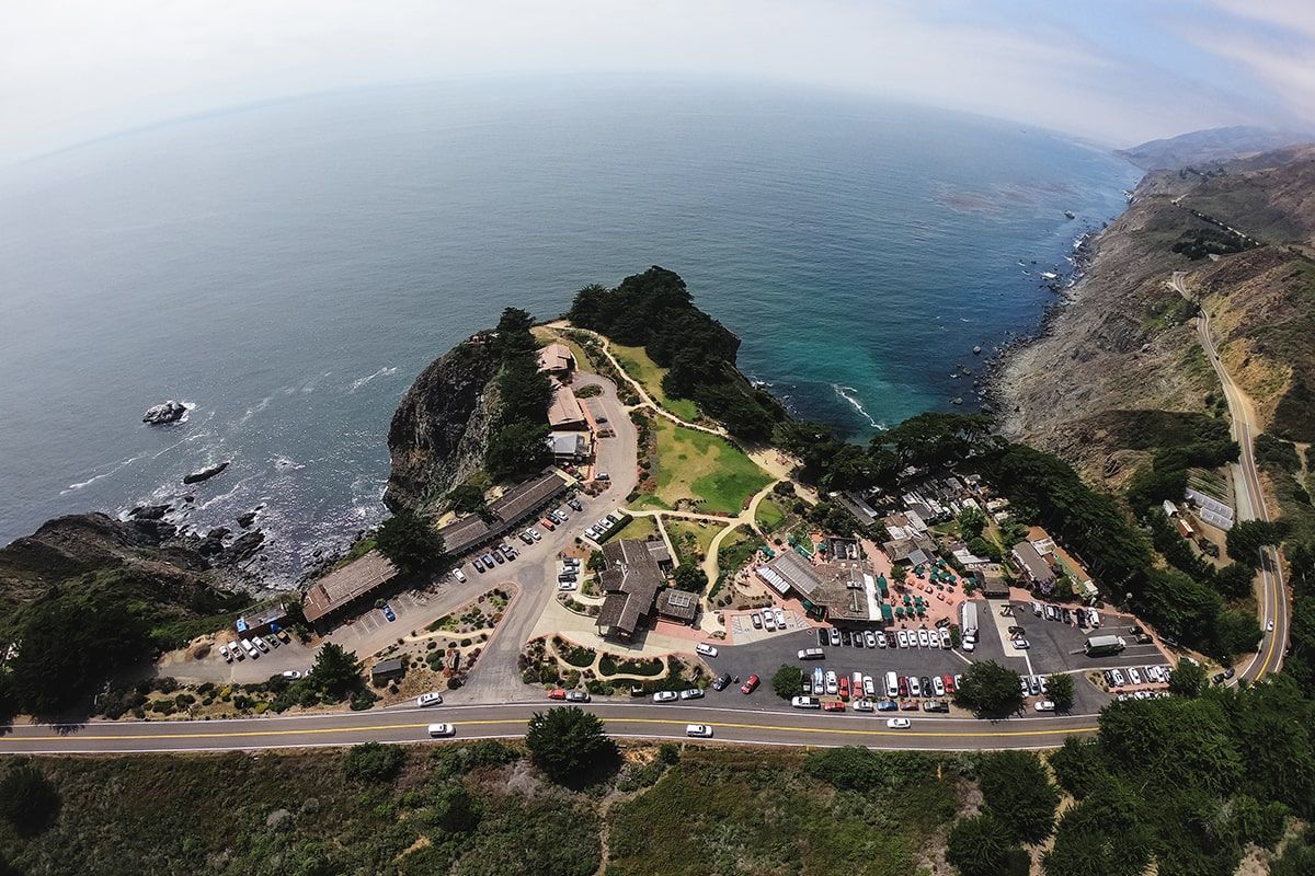
Ragged Point is a quaint community featuring a rocky headland with a scenic outlook. With seaside cliffs, beaches, and hiking trails, the area is unique in both its beautiful views and in the wildlife that calls it home.
It also boasts a black sand beach and the 300-foot Black Swift Falls seasonal waterfall. There’s the “Ragged Point” headland, a wide expanse of land along the Central Coast, but the main point of interest is the stunning cliffside view marked by the Ragged Point Inn & Resort.
Weather & Climate
While Ragged Point is part of the Central Coast, its weather is influenced by its place on a 400-foot cliff. It is prone to receive some of the Central Valley’s fog, which provides an entirely different cycling experience than normal coastal conditions.
The temperature high generally stays between 60° and 75°, with the occasional wind chill. The wind speed tends to be between 6 and 9 miles an hour. All that to say, it may be a good idea to bundle up!
Ragged Point History
The weather at Oso Flaco Lake usually stays between 73° and 43° year-round, but it can feel chillier with the wind coming across the water. It is always a good idea to check the tide levels before you visit, as this can limit the walking space on the beach.
Vegetation & Wildlife
The Piedras Blancas Rookery is an amazing place to view elephant seals in their natural habitat. The elephant seals spend time on this beach year-round with the highest populations in January, April, and October, but the best time to see pups is between January and March. Free and open to the public. The viewing rookery for these impressive creatures is a must-see on your ride to San Simeon.
The wildlife that lives around the beaches and inland trails in the Ragged Point area is plentiful. From birds to deer, there is always a good chance of an animal encounter. While it’s best to be cautious, most wildlife is safe to admire from a respectful distance.
Ragged Point Inn & Resort
From small beginnings, Ragged Point Inn & Resort has come a long way. Now, guests can choose to stay in cliff-side, cliff-top, and garden rooms. The resort also offers the Cliff House, which is a home-style lodging that can easily host a family or large group.
There are delicious dining options, including the Gourmet Restaurant and Wine Bar, Espresso Bar, and Sandwich Stand. For more special occasions, the resort has beautiful event facilities.
Where is Ragged Point?
Ragged Point is located on Highway 1, 15 miles north of San Simeon.
Highway 1 To Ragged Point
Highway 1 is the lifeblood of Ragged Point, leading to and away from the scenic point. The area provides an excellent stopping point while completing long rides along the highway from either San Simeon, Cambria, or Big Sur.
Ragged Point Directions
From the south, take Highway 1 north past the San Carpoforo Creek area and look out for Ragged Point Inn & Resort on your left. From the north, take Highway 1 south past the Salmon Creek area and look out for Ragged Point Inn & Resort on your right.
Cycling to Ragged Point
The Ragged Point Route is a 37-mile ride from San Simeon to Ragged Point on Highway 1 that passes scenic views and memorable landmarks. Some of the historic points that it is known for, other than Ragged Point itself, are Hearst Castle, the Piedras Blancas Light Station, the San Simeon Pier, and the elephant seals.
View the Ragged Point Route on Strava.
- Download the GPX file for the Ragged Point Route.
- Download the TCX file for the Ragged Point Route.
- Ride the Ragged Point Route with RideWithGPS.

What Should a Cyclist Expect?
Cycling Highway 1 to Ragged Point in the afternoon is a whole different experience due to the challenging winds. The weather can be cold and humid, so prepared for these conditions by dressing accordingly.
Another challenge of cycling on Highway 1 is navigating the turns in the road where motorists have less visibility. Make sure to wear reflective gear and test that your bicycle lights are working. It’s a good idea to regularly check that you are up-to-date on California’s road cycling regulations.
Dining at Ragged Point Restaurant
There may be only one good restaurant for miles, but that restaurant is famous on the West Coast! The Ragged Point Restaurant combines delicious California cuisine, professional service, and gorgeous views. With options that range from seafood to salad, there is sure to be a meal that satisfies you after the long ride.
Hiking Near Ragged Point
San Carpoforo Creek Trail
A 1-mile easy hike, the San Carpoforo Creek Trail is perfect for a relaxing excursion. With flat terrain, wildlife, and in-season wildflowers, the San Carpoforo Creek meets the Pacific Ocean in a spot that some refer to as a secret beach. Depending on the weather, there can be fair surfing conditions. But this is mostly a great spot to meander and stretch your legs.
Salmon Creek Trailhead
The Salmon Creek Trail leads to the Salmon Creek Falls, then continues on into a more secluded and quiet area of the woods. Traveling through lush coastal forestlands, this is a 7-mile hike. It goes up to Spruce Creek Camp and has a turnaround point at Estrella Camp.
Ragged Point Cliffside Trail
Short but famously strenuous, the Ragged Point Cliffside Trail is a challenging hike. Winding paths with epic ocean views lead to a hidden black sand beach and the base of the gorgeous Black Swift Falls waterfall. A half-mile trip with a 400-foot drop in elevation, this is a trail best explored by experienced hikers. If you’re up to the challenge, the view is well worth it.
Silver Peak Wilderness
The Silver Peak Wilderness is a large area—over 30,000 acres—that contains several hiking and backpacking trails that are worth discovering. The expanse of land was set aside as wilderness and is intended as an area where natural beauty is protected and preserved. Big leaf maples, California sycamores, coastal redwoods, and red alders are just a few of the trees that grow here. Some of the canyons have waterfalls when there is more plentiful water in the springtime, and on clear days the views reach to the Big Sur coastline to the north.
Cycle Central Coast also has a designated Silver Peak Route! This is a great way to enjoy the rugged wilderness without leaving your bike behind. Check out our page for route details.
Camping Near Ragged Point
San Carpoforo Campground
The San Carpoforo Campground is part of a 25-mile loop trail near the Big Sur area. This challenging route takes about 14 hours to complete, so it is a good chance to do some backpacking and camping. This official campground is inland of the San Carpoforo Creek Beach and provides amenities.
Silver Peak Wilderness
Campgrounds in the Silver Peak Wilderness are abundant, often conveniently located along the hiking and backpacking trails. If you want to spend the night so that you have more time to explore this protected area, check out these beautiful campgrounds.
- Upper Cruickshank Campground
- Lions Den Campground
- Buckeye Campground
- Estrella Campground
- Upper Salmon Creek Falls
- Salmon Creek Falls
Fishing Near Ragged Point
If you enjoy fishing, San Carpoforo Creek and the adjoining beach can be great spots. Before casting a line, it’s a good idea to check with local resources to make sure you are up to date with current regulations, including species limitations and the specific rules for wilderness areas and national parks.
Things To See Near Ragged Point
Ragged Point Scenic Views
The picturesque views from Ragged Point are incomparable. Often referred to as the Million-Dollar View, this spot is perfect for proposals, epic social media pictures, and just enjoying the beauty of the Central Coast. Ragged Point Inn and the Ragged Point Cliffside Trail are some of the best ways to access these views.
Black Swift Waterfalls
Black Swift Falls is also called Ragged Point Falls because it’s one of the treasures that you find at the end of the difficult Ragged Point Hike. One of the selling points of this hike, the waterfall only flows during rainy seasons, so it’s crucial to plan out your trip with that in mind. This area can also be partially underwater during high tide.
Portal to Big Sur
Near Ragged Point there’s a wooden sculpture known as Portal to Big Sur. This smooth, round structure has a whole in the middle of it that perfectly frames the Million Dollar View. This is a great place to rest before or after hiking. If you’re cycling through, take a minute here to appreciate the sights and take an awesome picture.
Salmon Creek Falls
When visiting the Silver Peak Wilderness, Salmon Creek Falls is one spot you don’t want to miss. Even in dry seasons, this large waterfall tends to have at least some water. Salmon Creek Falls is two separate streams of water that converge in one grand splash. It shares a name with a longer trail, but the waterfall itself is easy to see since it’s right off Highway 1.
Beaches Near Ragged Point
Young Creek Beach
At the bottom of the Ragged Point Trail lies Young Creek Beach. This black sand beach is surrounded by boulders and part of the area with Black Swift Falls. While you can see the beach from the bluffs where the trail starts, it doesn’t quite compare to experiencing it up close.
San Carpoforo Creek Beach
The secluded San Carpoforo Creek Beach is eight miles north of the Piedras Blancas Light Station, in the Hearst San Simeon State Park. Some of the fun things to see here are sand dunes and the creek, which comes close to the ocean.
If you want to do more than explore the area, it’s also a great spot for surfing, fishing, and beachcombing. The beginning of the Boucher Trail is also on the south side of the beach. The area is fairly easy to access if the tide is low, and you can park only a few minutes away.
Ragged Point Beach
Ragged Point Beach, confusingly, is not the black sand beach at the bottom of the Ragged Point Trail. It is actually located about 7 miles from the Piedras Blancas Light Station.
Due to trail erosion, the best way to enter this beach is from a narrow trail that starts off of Highway 1. This hidden spot is at a pull-out parking area, between a blue-signed call box and a “No Campfires” sign. The satisfaction from discovering it is almost as exciting as the journey to the beach itself.
Preparing To Visit Ragged Point
Whether you love to hike, are looking for a unique adventure, or just enjoy gorgeous views, Ragged Point is the perfect spot. From seaside cliffs to beaches to challenging trails to waterfalls, there’s something for everyone. This quaint community has everything needed for a vacation that is unplugged and focused on abundant natural beauty.

